


COPYRIGHT © 2016-2026. The Owl Teacher | Privacy page | Disclosure Page | Shipping | Returns/Refunds
Imagine if you could combine multiple math standards and integrate social studies at the same time. Imagine your students being so engaged that you wonder where this exciting activity has been all your life. That’s where this geometry map project came in!

In fourth grade, students have to know a lot of geometry! They have to focus on the types of angles, classifying 2D shapes, know lines, rays, segments, and so much more. They also have to focus on the lines of symmetry, just to name a few.
It can be a bit boring just teaching all of these various standards with worksheets. And I’ve always been into making math a bit more hands-on and project-based. For instance, you may have seen my real-life area and perimeter activity, designing a house. Students just simply learn better when it can be hands-on.
Creating the Geometry Map Project
To begin, I provide all my students with a math reference book. Together we go over all the geometric terms found on this given requirements page:

What’s really exciting about this page is that it contains more than just geometric terms. It covers important mathematical concepts such as partitioning rectangles into equal groups of 4 or 8, creating arrays, creating a congruent figure, creating an irregular polygon, and reviews the types of polygons from third grade. Even better, it covers measurement standards, by having students create roads that measure a certain distance- both in whole numbers and in fractions. (I’ve included both metric measurement and standard.)
Students are then provided with step-by-step directions on getting their map started – creating the compass, the legend, and the scale. They are also provided with examples of different places they can place on their map, such as a post office, a movie theatre, and a school.
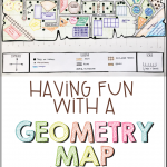
Students sketch out their map first before they transfer it on to their final paper. Once they have it all set to go, they can then officially design it, color it, and label it. Here is an example below of a finished map (and it’s provided in the resource):

Then if you desire- to differentiate- you can have students create a grid and an index. While I know coordinate graphing is a fifth-grade standard, it would be a great way to introduce it and it would help you find things much quicker on the map. In the resource, I provide step-by-step directions for students on how to create it and list the locations of everything on their geometry map (or index them).

If time allows, and if the teacher desires, the students have the option to find the perimeter of certain buildings in their town.
This resource also comes with a rubric to help teachers grade it.

You can find this engaging geometry map project in my store. Click here to purchase it on Teachers Pay Teachers.